
Lykkers, have you ever seen the sky turn dark, winds swirl wildly, and lightning flash like crazy? That’s the terrifying power of severe thunderstorms and tornadoes.
But what if we could spot these disasters before they hit the ground? That’s exactly what weather satellites orbiting Earth are doing every day—keeping watch over powerful storms from space to protect us all.
<h3>How Satellites Track Storms and Tornadoes</h3>
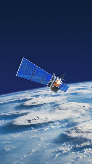
Weather satellites orbit high above Earth, capturing real-time images and data from the atmosphere. They use advanced sensors to detect temperature, humidity, cloud formation, and wind movement. When a storm begins to form, especially the kind that can turn into a tornado, these satellites spot the early signs—like rotating clouds and rising warm air.
Some satellites are placed in geostationary orbit, meaning they stay fixed over one spot of the Earth and scan the same area constantly. Others move around the planet in polar orbit, passing over different regions throughout the day. Together, they build a complete view of the planet’s weather systems.
<h3>The Tools That Make It All Possible</h3>
Satellites like the GOES series or Meteosat come packed with powerful instruments. One of the key tools is the Advanced Baseline Imager (ABI), which provides high-resolution images every few minutes. There’s also the Geostationary Lightning Mapper (GLM) that tracks every lightning strike in the storm. These tools help scientists understand how storms grow and where they might hit.
For tornado detection, satellites look for supercell thunderstorms—these are large, rotating storms with the potential to create tornadoes. Satellites can’t directly see tornadoes (they’re too small), but they give critical early clues by identifying dangerous storm conditions.
<h3>What Makes Satellites So Important for Safety</h3>
Tornadoes can form fast, sometimes in just minutes. That makes early warning extremely hard—especially with just ground-based radar. But satellites give us a head start. When they detect strong thunderstorms developing, meteorologists can issue alerts faster. This gives families more time to get to safety, schools a chance to cancel activities, and cities time to prepare.
Satellites don’t just help during the storm—they also help after. By tracking the storm path and damage patterns from space, they support emergency response teams and help organize aid where it’s most needed.
<h3>What We See from Space</h3>
From space, a powerful thunderstorm looks like a giant swirling system with thick clouds, spiraling winds, and bright bursts of lightning. It’s incredible to think that these satellites, orbiting thousands of kilometers above, can detect even the smallest temperature shifts or moisture levels that could signal danger.
Every 30 seconds, satellites can update data over storm zones. That’s like having a space-based weather station constantly feeding information to Earth.
<h3>The Future of Space Weather Tracking</h3>
Technology is moving fast. New satellites are being built with even more precise sensors and artificial intelligence to predict storm behavior. Some upcoming missions will let us see deeper into storms, track tornadoes even faster, and understand how climate change may affect severe weather.
In the future, we may even use satellites that work together in groups—sharing data in real-time to form a 3D model of the storm as it happens. Imagine being able to “walk around” a thunderstorm virtually before it touches down.
<h3>Looking Up, Staying Safe</h3>
Lykkers, next time a thunderstorm rolls in or you see a tornado warning on your phone, remember—high above us, weather satellites are working nonstop to keep us informed and safe. They’re like guardians in the sky, watching over the planet so we can better prepare for nature’s power.
What kind of weather event amazes or scares you the most? Let’s chat about it—because the more we know, the safer we all become together.
Detecting Tornadoes Early by Observing Lightning... from Space
Video by SciShow Space